Part I - Metal Detecting at the Swedish Tavern Site, page 7
A Few Words on Map Research for Treasure Hunting
Nowadays, finding an old map of the area in focus is not as important as finding the historical map which other treasure hunters do not have. This is a key factor in locating the "virgin" metal detecting sites! That is simply because the hard-to-find maps might carry an information that is missing on the maps used by everybody.
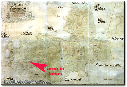
The Swedish 1704 map of Ingermanland shown below could be a good example of an uncommon map. It depicts the land that occupies an area of approximately 5,792 square miles (2,263 km²) - the size of Connecticut, and because of its high level of detail, just the map's digital size is huge - 8.2 feet x 4 feet (2.5m x 1.2m)!
Swedish 1704 Map of Ingermanland
Until recently, this map in high resolution could not be easily obtained on the web. By studying it and painstakingly comparing it to other maps of the period, I picked up some good leads. They had already brought my partner and I to a few productive metal detecting sites that had been unsearched before.
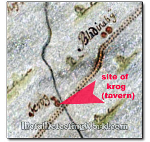
While studying the 1704 map, I discovered two potential metal detecting sites: one was a Swedish tavern ("krog" in Swedish) and another one was a village situated not far from the krog further down the road as shown on the map. I consulted the modern topo map to see if these two sites were "up for grabs."
First, to my disappointment, the tavern's site seemed to be buried under the modern railroad, and the village was destroyed by the industrial park. But my intuition told me that not everything might have been lost to the modern infrastructure, and I definitely had to do more "homework."
Finding another uncommon map, preferably of a larger scale and created within the same time frame, would greatly increase my chances in pinpointing this potential detecting site!
After browsing the web for hours, I finally found a map of a largest scale possible, which not only confirmed the location of a Swedish tavern, but, most important, allowed me to obtain the most correct distance measurements I needed for further research and calculations. The fragment of an earlier Swedish map, circa 1688, below shows the same krog situated at the small bridge or ford and a village that was larger in size back then.
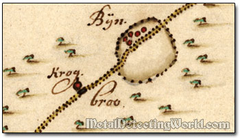
To prove that my intuition was correct, I had to determine the actual distances between the krog and surrounding landmarks - villages, creeks, road intersections, etc.(not shown on the map fragment above).
The late 17th and early 18th century Swedish maps carry the graphical scale expressing the ratio of a distance on the map to the corresponding distance on the ground in Scandinavian mile (mÿl) which equals to 36,000 feet (10,688 m). On the maps of a large scale, the distances are sometimes expressed in numeric fractions placed right on the roadways.
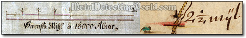
In any way, if you know the actual distance between the landmarks that are still present in the area, it is easy to calculate the ratio between the scale of an old historical map and the scale of a modern topographical map. After measuring the corresponding distance on a modern topo map and determining the location of the site, you can get the exact site coordinates (longitude and latitude) from the Google-Earth (though some researchers claim that it does not show the accurate coordinates) and then use your GPS to quickly find the site on the ground.
After measuring, calculating and recalculating various distances between different points on both old and modern maps, I came to my strong conclusion: even though the tavern site was situated very close to the railroad, it was still available for metal detecting! Now it was time to do some "ground work"!
You can read more about Map Research in my Complete Guide To Metal Detecting Research page.