Part I - Metal Detecting at the Swedish Tavern Site, page 6
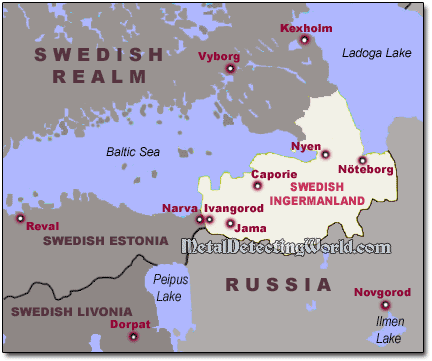
Swedish Ingermanland (Ingria) - a Swedish Dominion in 17th Century
Starting in the second half of the 16th century, Sweden increased its attempts in taking possession of Ingermanland. That would allow Sweden to complete a land bridge between Estonia and Finland, and bring the whole coast of the Gulf of Finland under Swedish occupation.
Ingermanland became one of the Swedish dominions first time during the Livonian War in the 1580s, was returned to Russia by the Treaty of Teusina ("the Eternal Peace with Sweden") to end the Russo-Swedish War in 1595. But in 1610, new war, the Ingrian War, broke out between Sweden and Russia.
At the end of the Ingrian War in 1617, Sweden achieved its main goal - the Treaty of Stolbovo stripped Russia of its access to the Baltic Sea and awarded the province of Ingermanland with the townships of Ivangorod, Jama (former Yam, now Kingisepp), Caporie (now Koporye) and Nöteborg (former Oreshek, now Shlisselburg) - the centers of the four long-existing Ingrian counties (slottslän in Swedish), back to Sweden. In the northern part of Karelian Isthmus, there were also Kexholm län with the center in Korela-Kexholm (modern town of Priozersk) and Vyborg län. Each center contained a stone fortress or citadel armed to withstand an attack at any time.
Swedish Ingermanland and Eastern Baltic Sea Region in 1658
According to the conditions of the peace treaty, local population should have stayed in their houses and under the power of the Swedish crown continue to live as before. But people of orthodox belief did not wish to live under a protestant king and a new church. Massive exodus started from Ingermanland to the Moscow realm. Ingermanland had become almost completely depopulated.
Attempting to fill the population void and to introduce Lutheranism, Sweden invited German colonists from the Baltic region, which politically was subjected to Sweden, to come and live in Ingermanland. But most of Lutheran gains were due to voluntary resettlements by Finnish peoples of Savonia from the south-eastern Finland and Finnish Karelia. The proportion of Lutheran Finns in Ingria (Ingrian Finns) increased from 41% in 1656 to 74% in 1695, the remainder being mostly Izhorians and Votes.
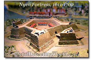
The only citadel built by the Swedes in Ingermanland was a fortress Nyen (Nyenschantz) erected in 1611 at the mouth of the Neva river, on the site of the present day St. Petersburg in Russia. This was a great strategic point for controlling the water route from the Baltic Sea to the Ladoga lake, which along with the river Volkhov had been a vital artery of Muscovy.
Nyen became the trading center of Ingria, and in 1642 was made its administrative center. In 1656 a Russian attack badly damaged the town, and the administrative center was moved to Narva in neighboring Swedish Estonia.
Ingermanland remained a dominion of Sweden for almost 100 years, from 1617 to 1708, until the area was reconquered by Russian army under the Tsar Peter The Great during the Great Northern War (1700-1721). With the Russians' overwhelming victory in this war finally came the end of all hostilities in Ingermanland. Peter the Great founded the city of Saint Petersburg amidst the land in 1703, which soon became the capital of the Russian Empire.
Forced to cede large areas of land in the Treaty of Nystad in 1721, Sweden also lost its place as an empire and as the dominant state on the Baltic Sea. In the 18th century, Sweden did not have enough resources to maintain its territories outside Scandinavia.
Most of them were lost, culminating with the 1809 loss of eastern Sweden to Russia. The area became the semi-autonomous Duchy of Finland in Imperial Russia. With Sweden's lost influence, Russia emerged as an empire and became one of Europe's dominant nations.
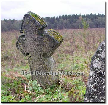
Ingermanland never formed a state, and the Ingrians had never been a nation because of the population's ethnic diversity: here the Novgorodian East Slavs lived side by side with Finnic tribes of Karelians (northwest), Izhorians and Votes (west), Veps (east) and Narova (west). Slavic neighbors had a strong influence on the Finns. Abundance of Novgorod style stone crosses dating back to 14th-15th centuries is one of the evidences of this influence.
Today, the historic Ingermanland is a part of the modern Leningradskaya Oblast which is Russia's "window" on the Baltic Sea, with St. Petersburg as its center. Many inhabitants of St. Petersburg region still recognize their Ingrian heritage.
300 years passed since Sweden controlled the Baltic region and Scandinavia, but the modern European treasure hunters and history researchers still get the greatest benefit of the 17th century Swedish occupation - accurate and detailed Swedish maps made during that period. Back then, the cartography followed the conquests, and the new conquests followed the cartography. The Swedish royal surveyors drew the most precise maps of the entire region. The basis for these maps was an almost fanatical devotion to detail and training.
While the cartography in the surrounding countries was still "in the womb" in the 17th century, the Swedish cartography had already "gained ground," became quite systematic and relied heavily on actual measured distances. The Swedish cartographers were the first to attempt thematic and topographic mapping, and their maps were so sufficient that they were used up until the early 19th century and still remain an important historic source for all types of research including the research for treasure hunting.