Metal Detecting Research and Exploration - A Complete Guide, page 51
Footwork and Observation
EXPLORING STREAM CONFLUENCES and WATERWAYS
Areas around stream confluences have proved to be great metal detecting sites because historically a lot of human activity took place at these sites in the past. Until the end of the Early Modern Period (1500s - 1800s), the land roads were scarce, and the waterways - rivers, creeks and streams, were the only means for transportation of goods and people.
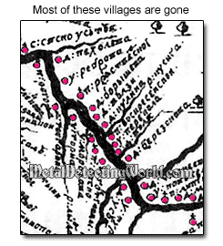
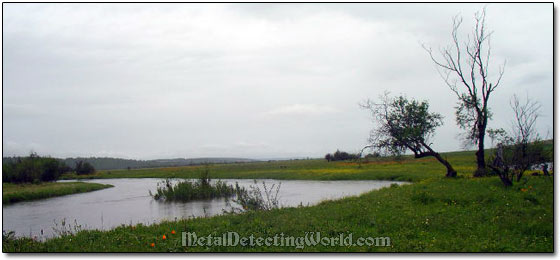
Almost in every culture throughout the early history of mankind, the majority of settlements were established along the waterways as shown on a picture on the right. At the river and creek confluences, there were founded the district centers - a large settlements or towns with churches and regional markets.
During the early American history, in particular, the stream confluences were the locations of the Indian trade-posts - centers of trading activity.
During the modern times in America, many picnic grounds were set up at the river confluences that were favored by the locals for picnicking, fishing and diving from the bridges built over streams and rivers.
You might want to read my story on Discovery of a Picnic Grove in Upstate New York.
Stream confluences are great spots not only for coin shooting but also for relic hunting, whether you hunt for pre-historic artifacts or for the WW2 relics. There is a simple reason for that: every stream confluence is a good strategic point and would be a desirable spot for any militant group or army. That is why many small forts and redoubts were built at these locations.
A great attention should be also paid to the stream crossings, whether they are the former bridge sites or just fords. At these spots, the improvised rest-areas were established where horses and people could rest and use water for cooking, bathing and horse-washing. Also many coin caches have been discovered under bridges or near their remains. For example, when the band of robbers was chased by sheriffs, and the bandits did not have time for hiding their heavy loot which slowed them down, they would drop it off the bridge. Sometimes they did not come back to the spot to retrieve their bloody rewards. Also the spots at which the road comes very close to the creek or river should be thoroughly investigated for the same reason.
The banks of streams that are flowing down the steep terrain should be searched for sawmills and tanneries. Before the age of steam engines, the natural water power was used everywhere. Every small settlement that was situated in the forested mountainous region had a sawmill and/or mills of other types. For instance, I have discovered remains of many sawmills located way up, sometimes at the 2,000 feet elevation, in the Catskill Mountains in Upstate New York.
One should not forget about a recreational use of rivers and lakes throughout the history of mankind. If you locate the site of old ferry crossing, boat landing or local market place on the river bank, most likely, the site of an old swimming spot (or "swimming hole") is adjacent to it. And it could be a few centuries old!
Back in the medieval times, the local fairs were often set up at the "river market" spots - flat and spacious plats, which were perfect for gathering of large crowds. It was common that at the end of the hot trading day, the masses would drink, dance, fistfight, and then go skinny-dipping.
A Fragment of 1590 Lithograph Showing the "End of a Good Day" :)

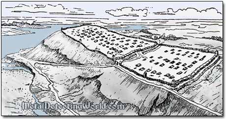
At last, the high river banks with capes and sharp river bends should be mentioned. These spots turn out to be the sites of the former fortified settlements of the cape type or simply medieval villages in 80% of cases. During the medieval times, people settled on high river banks due to continuous military tensions. Their fortified settlements were defended by ramparts and moats and housed from 80 to 200 people. Their economy included agriculture and cattle breeding. When the settlement population grew large, a few small villages were built around the fortified settlement which served as a hideout during the militant raids or sieges conducted by the foes.
A Typical Promontory Fortified Settlement, circa 8th Century, on a High Cape
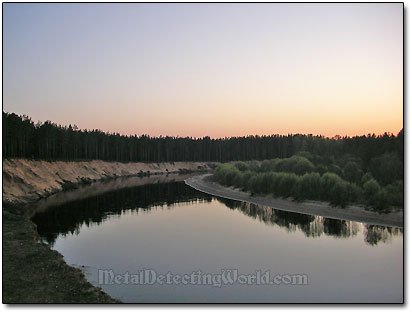
The sharp river's bend also represents a good strategic point as the river can be easily observed in both directions, so no unfriendly vessels would approach without being spotted in advance. The sharp river curvature would provide an excellent opportunity to easily aim and fire a cannon in any direction of approaching ship. A village situated at such advantageous location would never be an easy prey for enemies.
River Bend Viewed from High Bank
On the contrary, the village could control the passage of merchant vessels and collect "tolls" for passing through. Metal detecting at one of such locations is described in my story Metal Detecting Trip to the Ghost Village Manzurka (Story 9).
Site of the 18th Century Village at River Bend