Metal Detecting Research and Exploration - A Complete Guide, page 23
Understanding Map Scales on Historical and Modern Topographical Maps
The scale of a map is the ratio of a distance on the map to the corresponding distance on the ground. The scale indicates the standard of measurement that is being used so that the relative size of elements on the map can be determined.
Map scales may be expressed in four ways:
1) in words - a Lexical Scale, for example, "one centimeter to five hundred meters"
2) as a Ratio: 1:50,000; Sometimes the ratio may be abbreviated: 1:100,000 to 1:100K
3) as a Representative Fraction (RF) (also called Principal Scale): 1/50,000
4) in a graphical form - a Bar Scale (also called linear scale)
Lexical scales have become obsolete on modern maps. Ratios and Fractions are much more acceptable since they are immediately understood in any language. Ratios and Fractions are versatile because you are not tied to any specific units of length measuring. You may work in any unit you choose: metric, English, or other.
Bar Scales are the most appearing scales on both historic and modern maps. The length of the line on Bar Scale is equal to the distance represented on the earth multiplied by the map's scale. This is very helpful when you work with a digital copy of the map that might have been photographically or electronically enlarged or reduced.
That is why the bar scales are the most useful in measuring real-world distances on the map. A person using the map can use a pair of dividers or compass to measure a distance by comparing it to the linear scale.
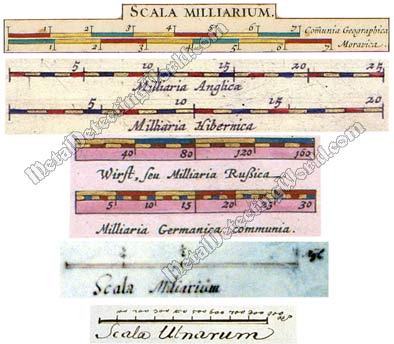
Various Bar Scales, Small and Large, of European Historic Maps, ca. 1630s
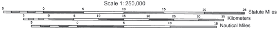
Here is an example of the modern map scale expressing three bar scales for kilometers, miles and nautical miles.
Modern Graphic Bar Scales
NOTE: It is important to remember that most photocopiers are able to easily enlarge or reduce a printed map. Also the map can be turned into an electronic form - scanned or digital map, to be used on the web. When either of these happens, it is important to note that:
1. the Scale Bar will remain correct, i.e. the correct proportional relationship between the elements of the map and the scale will be maintained
2. the written Statement of Scale (a lexical scale) will not be correct
Map scales are often qualified as small scales, typically used for world maps or large regional maps, or large scales, typically used for county maps or town plans. The usage of "small" verse "large" relates to the expressions as fractions. For example, the large-scale topographic map may have a scale fraction of 1/50,000 which is much larger than a scale fraction 1/100,000,000 used for the small-scale world map. There is no hard and fast dividing line between small and large scales.
On the small-scale maps, such as the world map, where the scale of a map is highly variable and/or distorted away from the standard parallel(s) due to the curvature of the Earth, an additional information is supplied with the Statement of Scale/Scale Bar. Most commonly this involves supplying location information about the scale. For example: "scale at 20° North or South is..."
The distance measurement of a map tells you how many units (cm or inches) on the ground equal to 1 unit (cm or inch) on your map. The distance measurement of any map can be easily determined from the map's scale expressed as a fraction.
For example, if the map scale states 1:50,000, in other words, "1 centimeter on the map is equivalent to 50,000 centimeters on the Earth," you divide the number 50,000 by 100,000 - which equals to 0.5 or 500 meters, i.e. 500 meters to 1 cm. In a similar way, with a map scale of 1:100,000, we divide 100,000 by 100,000 and get 1, which means 1 kilometer to 1cm.