Metal Detecting Research and Exploration - A Complete Guide, page 28
Basic Calculations Used in Map Research
DETERMINING THE SCALE OF A DIGITAL HISTORIC MAP - TUTORIAL
(CONTINUED from Page 27)
When you work with maps on your PC or laptop, make sure that every time you open the maps in the image viewer or Photoshop (I usually use both to view several maps at the same time), you set up the magnification of map images on the same level - 100%, 150% or 200%.
To increase or decrease the magnification level of the map images, use the Zoom In or Zoom Out icons in your image viewer, the magnification value is usually shown in the bottom of the image viewer window, or the Zoom Slider at the bottom of the Navigator Palette in Photoshop. To access the Navigator Palette, click on the Navigator Palette tab. If the Navigator palette is not showing, go to the Window menu and select Show Navigator.
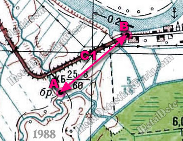
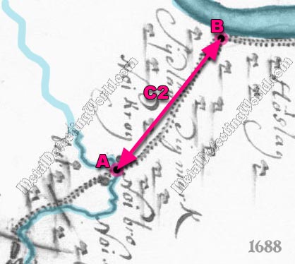
I set the image magnification level of both maps on 100%. Now I measure the distances between the two points - A and B, on both maps and name the obtained distances as C1 - for topographic map, and C2 - for historic map (shown on maps below).
NOTE: You should use a paper topo map because the value of C1 measured off the computer monitor is larger than it would be if measured on the paper topo map. If you do not have a paper topo map, it is important first to determine how many meters on the ground are represented by 1 cm on the topographic map displayed on your computer at 100% magnification. Divide the known distance on the ground by the distance between the same control points on a digital map and use the obtained fraction (for example: 1 cm / 160 m) for further calculations.
Fragment of 1988 Topographic Map
For this map analysis tutorial, I rotated (oriented) my historic map to align it with North-South directions.
Fragment of Historic 1688 Map
Now it is time for simple arithmetic. First I calculate the actual distance between points A and B on the Earth by this formula (explained on Calculating Ground Distance from Map with Lexical Scale page):
![]()
where:
C1 = 1.6 cm - distance between points A and B on topographic map,
D (m) - actual distance between points A and B on the Earth,
"500 m / 1 cm" - inverted fractional expression of a Lexical Scale ("1 centimeter represents 500 meters") of the topographic map.
![]()
NOTE 1: I could obtain this value by simply using the web-based Google Earth provided I have installed the necessary plug-in on my PC or laptop. The plug-in can be downloaded from the this web site: http://www.newestsoft.com/Windows/Home-Hobby/Other/Google-Earth.html (copy the link and paste it into your browser window).
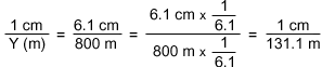
Now I calculate the approximate lexical scale of a digital historic map by this formula:
![]()
where:
"1 cm / Y (m)" - a fractional expression (RF) of the historic map's lexical scale,
Y (m) - ground distance represented by 1 cm on a historic map,
C2 = 6.1 cm - distance between points A and B on historic map,
D (m) = 800 meters - actual distance between points A and B on the Earth.