Metal Detecting Research and Exploration - A Complete Guide, page 30
Basic Map Analyzing and Studying Techniques
The map studying is based on comparing various maps, both historic and modern, for change detection. The map comparison can be done either by the Map Overlay method or by minute visual inspection of maps if you are good at map reading. A simple version of the latter is described in chapter 1 - "Map Research with Old US Maps," on page 2.
Maps Overlay
Map Overlay is the simple means to see the changes in any particular area. It is done by placing a historic map over a modern topographic map (a reference map) or overlay it with more recent satellite images downloaded from the web. Map overlay can be done in three ways: 1) by using an expensive translucent (not transparent but clear enough) drawing film or less expensive waxed paper, 2) by overlaying the map images in the graphic editor, such as Photoshop, on your PC, and 3) by using the web-based map rectifier.
The former is an outdated method and not something you can learn in a short while. You have to practice it for a long time before you begin to figure out how it works. Basically you create the hand-drawn copy of the original historic map. Your copy should never show all information that the original map contains - it would get too messy. First, you put a protective plastic between the historical map and your transparent film, and then draw objects on it with a soft pencil. You draw only the information you believe you can benefit from: land, houses, fields, meadows, pastures, rivers, roads, fencing, etc.
The second method is easier and less erroneous, and anyone can do it without being a pro in map overlaying. The advantages in using the electronic map overlay are the following: you can easily correct any mistakes, change the transparency of images, make one map-image in black and white, increase or decrease the map sizes (so the maps would match), rectify a historic map, rotate the map images, include or exclude any details, and use more maps at the same time.
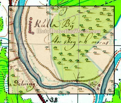
Below is an example of simple map overlay by means of the graphic editor Photoshop. First set of maps includes a historic 1689 map of a scale 1:10,000 (1 cm on map equals to 100 m on the ground) and a modern topographic map of a scale 1:50,000 (1 cm on map equals to 500 m on the ground).
Two villages are depicted on a historic map: Kulla bÿ and another village (in the lower right corner) just marked by the word village - bÿ (swe.). By the map overlay method, I can determine the exact locations of these village sites on my topo map, and later get the longitude and latitude coordinates for GPS navigation.
Two Map Fragments To Be Used for Map Overlay
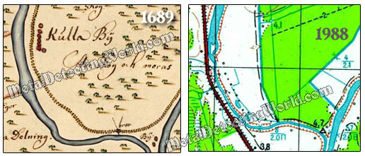
With Photoshop, I easily adjusted the historic map image to fit into the image of a topo map by doing the following: reduced the map's size, rotated the image and warped it a little. All my actions - rectification of an image (explained on following pages), resulted in this nice map overlay shown below.
A Fragment of 1689 Map Overlaying the Topo Map Fragment