Metal Detecting Research and Exploration - A Complete Guide, page 8
Map Research for Locating Treasure Hunting Sites in Europe
A Few Facts on European Cartography of the Early Modern Period (AD 1500 - AD 1800)
Due to the numerous and continuous war conflicts that have ravaged the continent, the map cartography in Europe had developed fast and got pretty advanced by the mid-17th century.
Back in the 15th century, a systematic work was started to register land holdings in Land Books - early cadastres. During the reign of Swedish king Gustav Vasa (1523-1560), the surveying and mapping was improved in order to facilitate the assessment of farms and tax collection for the Crown.
In the early 17th century, Sweden took a leading position in creating the most accurate and detailed maps of the entire Baltic Sea region and Scandinavia as the Swedish Empire with its advanced army was taking new territories one by one and turning them into its dominions.
The cartography followed the conquests, and the new conquests followed the cartography.
Despite their accuracy and modernity, the new maps still could not match the detailed descriptions given in the Land Books. To make the most accurate assessments of the newly acquired lands, King Gustav II Adolf of Sweden decided to set up a National Land Survey.
In 1628, he gave Anders Bure - "the father of Swedish cartography", the task of creating the Swedish Land Survey, educating land surveyors, and carrying out a systematic mapping of the Swedish Realm. The Land Survey organization was to survey and draw maps showing all parishes, counties, provinces, farms and villages, towns, industries, mines, ports and harbors, lakes and rivers in high detail. A distinction was made between two types of surveying and mapping: geometric (depicting villages at a largest scale possible) and geographic (depicting parishes and districts at the next-to-largest scales).
Both types of surveying and mapping were continued beyond the border of Sweden even after the Great Northern War (1700-1721) in which Sweden was defeated. Created three centuries ago, the Swedish historic maps of both types are still credited as the most sufficient maps by modern researchers and considered to be the "gold mines of historical information" by treasure hunters.
A few excellent historic maps were published by other renown European cartographers, such as Johannes Jansonius (1588-1664), Hendicus Hondius (1597-1651), Willem Jansz. Blaeu (1571-1638), Joan (1598-1673) and Cornelis Blaeu (1610-1646), John Speed (1552-1629), Martino Martini (1614-1661), Nicolaas Visscher II (1649-1702), in the 17th century.
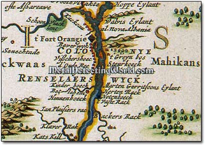
These maps also evoke a great interest among both European and North-American treasure hunters because they depict areas of both Old and New Worlds. Below is an example - a fragment of map of New England published by Johannes Janssonius in 1651.
A Fragment of 1651 Map Showing Fort Orange (now Albany, NY) and Villages Situated along Hudson River
Swedish Empire collapsed at the end of the Great Northern War and lost most of its dominions. In the eastern Baltic Sea region, Russian army of the tsar Peter The Great reconquered all territories that belonged to Russia before the Swedish occupation. As soon as Russia regained its access to the Baltic Sea and naval trade routes, new economical, administrative and social changes took place in the region.
Now Russia was emerging as an empire. Many ambitious economical projects were put into motion by Peter I The Great, and they required new land and naval maps or nautical charts (graphic representations of a maritime area and adjacent coastal regions).
Building a new naval fleet for Russian Empire was one of the biggest projects which required a lot of timber suitable for building ships. This project demanded a largest number of new maps of forested land, an army of trained cartographers and new methods of mapping. The regional cartography picked up a new momentum, and the European mapping techniques were used as a foundation for further developments in cartography.
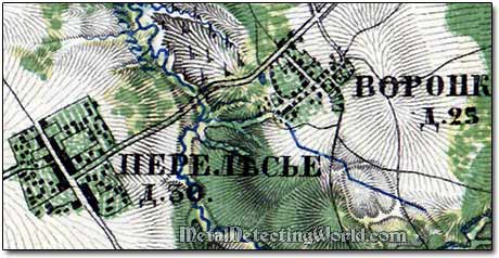
Within next 100 years, the land surveying, map designing and map production were carried out on a regular basis. In the mid-1800s, the Imperial Russian Cartographical Society began issuing atlases of military-topographical maps of high quality and detail. These large-scale maps cover all districts of the north-western region of Russia. The best example of the 19th century Russian cartographic series is the 1860 atlas which has been the "bible" for modern treasure hunters.
A Fragment of 1860 Russian Large-Scale Map Showing Two Villages in Details