Metal Detecting Research and Exploration - A Complete Guide, page 14
Map Research for Locating Treasure Hunting Sites in Europe
IMPORTANT SPECIFICS
5. Settlements that Disappeared by 18th Century
Due to the natural changes in terrain or changes caused by vast man-made economical projects (draining marshes by digging lots of reclaiming canals, massive felling of building timber, woodland clearing to expand the farmland, etc.) that ocurred during the 18th and 19th centuries, the sites of settlements that had disappeared by the 1700s are harder to locate than the sites of settlements that existed a century longer.
Maps issued in the pre-18th century periods help a lot in discovering such sites.
If historic maps are not available, one has to find other historical sources which would mention and describe the locations of villages established in any specific area at that time. Or one has to conduct a lot of footwork (transect).
While transecting the area, one can either look for any cultural features - signs of former human activity, or scan the ground with a light-weight metal detector for possible signals at the spots that appeal to be promising.
Those settlements which were abandoned even earlier - during the Late Middle Ages, typically left no traces apart from remains of earthworks or crop marks (explained on page 61). Even though the deserted medieval villages are hard to research and locate, the number of them is staggering and makes a serious treasure hunter keep researching and looking. For example, there are estimated to be more than 3,000 deserted medieval villages in England alone. Here is another fact: before 1350, there were about 170,000 settlements in Germany, and this had been reduced by nearly 40,000 by 1450!
The best example of a good toponimical source for leads to locations of the pre-18th century settlements in the eastern Baltic Sea region is a book called Land Register. For example, in post-medieval Russia, Land Books were regularly issued by the Novgorodian Republic which controlled vast territories of the North-East.
A Page Fragment of Swedish Land Register Book, circa 1647
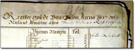
Each issue was a fine combination of cadastral (showing and describing the boundaries and ownership of land parcels) and census data for each district. Each book included the following: descriptions of every village and town with details of the ownership, their locations, their dimensions and square areas, and fields and meadows, both active and abandoned, owned by landlords. Each field is numbered and described with type and soil.
The Land Register also listed all residents in each settlement along with their social statuses or trades, and gives a full inventory of each homestead and its cattle for proper taxation. Land descriptions of the whole state and its provinces were planned and fulfilled by the staff of Administration of Estates.
Today, if located in the rural area, almost every site of the settlement that disappeared before the 18th century would be situated in the farm field, either cultivated or abandoned. That is why it is essential to obtain as many historic maps as possible to pinpoint the exact location of this site on a modern topo map, determine the site's GPS coordinates, and use modern software such as OziExplorer GPS Mapping Software (described on page 38) for finding the hunt site on the ground fast.
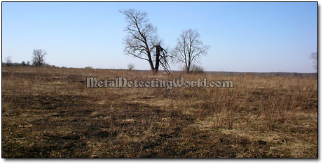
A Large Village Stood Here 350 Years Ago
If you know the actual ground distance between the landmarks that are still present in the area and depicted on a historic map, it is easy to calculate the ratio between scales of historical and modern topographical maps (more info about the map scales is given on page 23). Then you determine the corresponding distances on a modern topographic map, pinpoint the exact location of the site on it, and get the site's GPS coordinates (longitude and latitude) from the Google-Earth. Then you use your GPS unit together with your laptop (to view a Moving Map through OziExplorer) to quickly find the metal detecting site in the field.