Metal Detecting Research and Exploration - A Complete Guide, page 39
Using OziExplorer GPS Mapping Software for Locating Hunt Sites
GPS
In order to use OziExplorer for real time tracking ("Moving Map" mode), you need to run it on your laptop that is connected to a GPS unit or has a GPS module attached.
In the former case, it is better to use a USB connector that can both provide electrical charge for GPS navigator and channel information back and forth between GPS and laptop.
OziExplorer provides direct support for most Garmin, Lowrance/Eagle, Magellan, Silva/Brunton and MLR GPS receivers for Uploading and Downloading Waypoints, Routes and Tracks.
You can create Way Points, Routes and Tracks directly on a map for upload to the GPS unit. When you download Waypoints, Routes and Tracks from a GPS, they are displayed on the loaded map.
WAY-POINTS
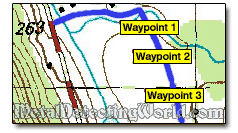
A waypoint is a set of latitude and longitude coordinates with a name. You can view a waypoint on the map, navigate to it or use it in a route. By default OziExplorer usually just gives each waypoint a number in sequence as you create them - 01, 02, 03, 04... You can rename them.
With OziExplorer, you can load up to 10,000 waypoints to your map, position them on a map, add them to a route, and keep an unlimited number of way point files. If you create a Waypoint List, you can locate waypoints on the map from the list. Then you can navigate to a waypoint or navigate along a predefined route.
A waypoint and a route file can be attached to any map and will automatically load when the map loads. Attached files may include short descriptions of the hunt sites including historical info, types of coins and relics assumed to be found, or your record of all finds discovered at each location.
For navigating along the routes, creating extra waypoints may be very useful. If you create waypoints just before and just after an intersection of abandoned roads, you will know which way you are going upon exiting the intersection. The waypoints that are set up before the intersection can be used in case you want to reverse the direction of navigation.
OziExplorer will allow you to Export and Import waypoints to/from a text file, a GPX file, and a Google Earth KML file.
ROUTES
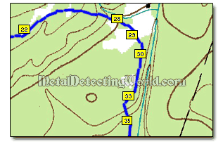
A route is a set of way points. You will automatically move from one waypoint to the next until you reach the destination waypoint. The Route is created by connecting the waypoints together. By default, OziExplorer will connect them in the order you created them, but you can change the order as you define the route, leaving out some waypoints if you like.
When you instruct the OziExplorer to display the "Route," OziExplorer will first display the waypoints and then join them up with straight lines. If you choose to "Navigate" the route, OziExplorer will tell you how far to the next waypoint, what is your bearing, and how long it thinks it will take you to get there.
You can create/load up to 100 routes on the displayed map by attaching up to 250 waypoints to the route, save routes to file (an unlimited number of route files can be created), and upload/download routes to or from a compatible model of GPS (OziExplorer provides automatic configuration to match your GPS).