Metal Detecting Research and Exploration - A Complete Guide, page 3
Map Research for Locating Treasure Hunting Sites in the US
BASIC MAP COMPARISON
(CONTINUED from Page 2)
Beer's maps are scaled 160 rods to the inch (or 1/2 mile to the inch) which makes it easier to measure distances and locate cellar holes on the ground. This might be essential in the cases when the torrential rains changed the terrain dramatically, or dense vegetation has made the cellar holes invisible, thus making their discovery a difficult task for a treasure hunter.
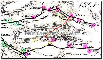
The following picture depicts a fragment of the map which was issued seven years later, in 1861, and, for example, shows fewer houses on the upper road. The fact that some homesteads had disappeared by the mid-1800s means that there would be no modern junk found around the remaining cellar holes and foundations of those houses. Also, older coins and relics could be found there.
A Fragment of Beer's Map Issued in 1861
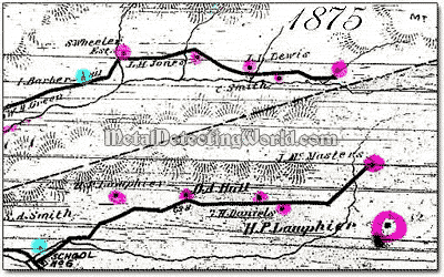
And finally, here is the last map of Beer's Atlas or map series, which was issued in 1875. It shows absence of one more house on the same segment of the upper road which is depicted being extended eastward a little - just over the fourth tributary, while a house shown at its end on 1861 map is now absent (it most likely burnt down). Instead, a newer house appears on another side of the creek.
A Fragment of Beer's Map Issued in 1875