Metal Detecting Research and Exploration - A Complete Guide, page 29
Basic Calculations Used in Map Research
DETERMINING THE RF SCALE OF A DIGITAL HISTORIC MAP - TUTORIAL
(CONTINUED from Page 28)
NOTE 2: Theoretically, the denominator of resulting fraction should be rounded so that it does not imply more accuracy on the map RF scale than the original precision warranted. But it is sometimes important to keep the number "as is" for getting more realistic results from further calculations.
To obtain the Representative Fraction (RF)/Ratio Scale of the historic map displayed on a computer screen, I solve this equation:
![]()
or 1:13,000
Now the approximate Lexical Scale of a digital historic map has been determined as "1 centimeter represents 130 meters" or as a Representative Fraction (RF) Scale - 1/13,000, or as a Ratio Scale - 1:13,000.
NOTE: The calculated scale is not the actual scale of the same historic map printed on paper. It is only a scale of a digital historic map displayed at 100% magnification on your computer. You can determine the true map scale only when both maps you use are printed on paper.
If it is possible, do the same calculations with more pairs of control points. That would allow you to see if the map errors are relatively uniform in surrounding areas on the map, so you could take them into account when calculating the average out of all values obtained. And then hopefully you will be able to determine the real-world distances between the objects shown on a historical map.
NOTE 3: To measure the distances of the curved roads and waterways on the map correctly, use a Map Measurer. And again, do not forget to keep the same magnification every time you work with maps in the image viewer.
NOTE 4: This method assumes that these two participating locations are at the same elevation, or that the terrain is flat. If there are hills, even moderate ones, in the area in focus, the calculations can be thrown off.
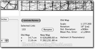
The easiest and correct way of determining the historic map's scale can be done by using MapAnalyst software. The MapAnalyst application is primarily used for the visualization and study of the planimetric accuracy of historic maps. It illustrates local map distortion by generating distortion grids, displacement vectors, and new isolines of scale and rotation.
Also MapAnalyst additionally computes the historic map's scale and rotation, as well as statistical indicators summarizing the map's geometric accuracy. It offers a user-friendly interface and is freely available for all major computer platforms at http://mapanalyst.cartography.ch/ (copy the link and paste it into your browser window) or other places.
An analysis with MapAnalyst begins by importing images of an old map and a georeferenced modern map. Then you identify corresponding locations on the two maps and interactively place pairs of points at these locations. Computing the scale of a sub-area of the map is a matter of seconds.
MapAnalyst