Metal Detecting Research and Exploration - A Complete Guide, page 17
Map Research for Locating Metal Detecting Sites in Europe
IMPORTANT SPECIFICS
6. Colors, Symbols, Terms and Legends Used on Historic Maps
In the late 1500s, for better representation of the area depicted, the European maps began to be drawn in conventional colors: cultivated land was to be gray, meadows green and mires yellow.
Lakes edges were to be light blue, while rivers and streams were to be drawn in a darker blue color.
Forest was to be green and mountains and hills were shown in brown or left uncolored. Boundaries were to be marked in red and fences in black.
Of course, these colors may slightly vary from map to map, especially if their tints have changed with time, however, the conventional map colors have not changed much since the 16th century.
While studying a variety of foreign historic maps, it is vital for any researcher to know the exact translations of basic terms - "district", "county", "parish", "village", "mill", "bridge", "ford", "tavern", etc., that are shown on historic maps and written in foreign language.
Sometimes the basic terms or their abbreviations are inscribed in one word with place names on the maps. On Swedish historic maps, most of such cases include two terms: bÿ = village, and hoff = manor. For example, Alenabÿ = village of Alena. Alena bÿ should be written instead.
The problem arises when the terms are written in the outdated language, and even the on-line translators cannot help. In this case, you solely rely on your abilities in logical and analytical thinking. If no translation is available, try to find a modern word which resembles the spelling of a particular term and is in accord with what the map shows. Sometimes the spelling of the same terms slightly varies even on maps of the same linguistic origin.
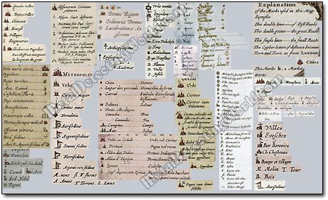
The map symbols are the most helpful in determining the meanings of terms and legends written on maps. It is much easier to interpret any historical map if you know the conventional symbols and colors used for representation of cultural and natural features.
Map symbols are usually depicted in the boxes shown on historic maps and called Notarum Explicatio, Notarum Descriptio, Notularum Explicatio, Caracterum Explicatio, Caracterum Huius, Tabulae Explicatio, Notat, Sigrorum Declaratio, etc. If you use different types of old historic maps of various scales for your research, it is best to compile all the historic map symbols of the period in one chart for your references.
Example of My Chart of Historic Map Symbols Used on European Maps in 17th Century